


Delta Junction Precinct, Southeast Fairbanks Census Area, Alaska
About
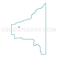
Outline

Summary
| Unique Area Identifier | 523528 |
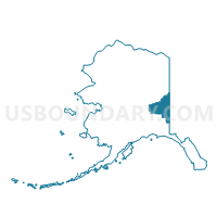
| Name | Delta Junction Precinct |
| County | Southeast Fairbanks Census Area |
| State | Alaska |
| Area (square miles) | 16.82 |
| Land Area (square miles) | 16.82 |
| Water Area (square miles) | 0.00 |
| % of Land Area | 100.00 |
| % of Water Area | 0.00 |
| Latitude of the Internal Point | 64.06026270 |
| Longtitude of the Internal Point | -145.69352870 |
Maps

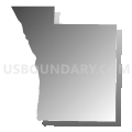
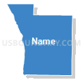
Graphs
Select a template below for downloading or customizing gragh for Delta Junction Precinct, Southeast Fairbanks Census Area, Alaska


Neighbors
Neighoring Voting District (by Name) Neighboring Voting District on the Map
- Big Delta Precinct, Southeast Fairbanks Census Area, AK
- Deltana Precinct, Southeast Fairbanks Census Area, AK
Top 10 Neighboring County Subdivision (by Population) Neighboring County Subdivision on the Map
Top 10 Neighboring Place (by Population) Neighboring Place on the Map
- Deltana CDP, AK (2,251)
- Delta Junction city, AK (958)
- Big Delta CDP, AK (591)
- Fort Greely CDP, AK (539)
Top 10 Neighboring Unified School District (by Population) Neighboring Unified School District on the Map
Top 10 Neighboring State Legislative District Lower Chamber (by Population) Neighboring State Legislative District Lower Chamber on the Map
- State House District 12, Richardson-Glenn Highways, AK (14,811)
- State House District 6, Interior Villages, AK (14,235)